


Nearly 97% of the existing McCall Impact Area should become part of unincorporated Valley County, the Board of County Commissioners said last week.
The commissioners outlined a plan that would remove all but a handful of parcels from the impact area, a planning boundary for lands that are likely to become part of the city within five years, under state law.
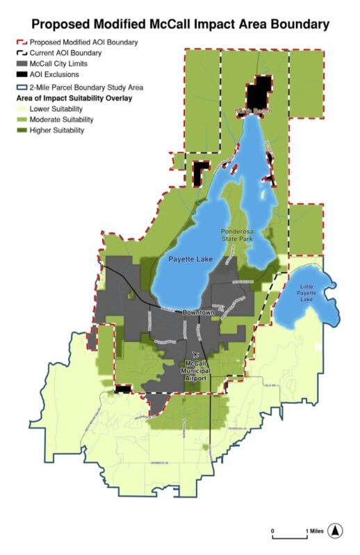
The county’s planning department will present the updated proposal, along with a map, during a public hearing on July 7 at 2 p.m. If adopted, the new boundaries would take effect later this year.
The county’s plan follows a formal proposal by the City of McCall that favored keeping the boundaries largely the same as they are today.
Overall, the county’s plan would reduce the size of the impact area from more than 22,000 acres currently to about 684 acres, or by about 97%.
The new boundaries would include 135 acres around the McCall Municipal Airport, 90 acres in southeastern McCall on which Pine Creek Ranch is proposed by developer Craig Groves of Donnelly, and two state land parcels off Lick Creek Road near Pilgrim Cove.
Land surrounding Payette Lake would not be part of the impact area anymore, under the county’s proposal.
County governance
The county also plans to take control of development application reviews in the impact area instead of continuing with a joint review process with the city that has been used for decades.
“The biggest thing I’ve heard from constituents out there is they’re tired of confusion in the impact area,” Commissioner Neal Thompson said. “We take over the governance and it takes care of this whole confusion we’ve had all along.”
Commissioner Katlin Caldwell agreed with Thompson, calling the consolidated governance “cleaner.”
If adopted, all impact area development applications would be reviewed under county zoning codes by the Valley County Planning and Zoning Commission.
Currently, the seven-member McCall Area Planning and Zoning Commission reviews applications and makes recommendations to the county commissioners based on codes that closely resemble those in place within city limits. The McCall P&Z includes three impact area representatives who are appointed by the county.
Besides the confusion cited by Caldwell and Thompson, Commission Chair Sherry Maupin said the joint approach is a legal risk to the county and could require hiring a lawyer to staff all hearings involving the impact area.
“It’s cost-prohibitive for the rest of the community in order to do that on a small impact area,” Maupin said.
The proposed changes to the McCall Impact Area mirror how the county administers impact areas for the cities of Cascade and Donnelly.
State law
Maupin emphasized that the county’s proposal is underpinned by a new state law that prescribes criteria for defining impact area boundaries. Among the criteria is the availability of water and sewer service, which Maupin said was a key factor in McCall.
Without donors like you, this story would not exist.
Make a donation of any size here
“Residential growth in these areas, and commercial growth, is all limited to sewer right now,” she said.
The other criteria include anticipated growth, geographic factors, transportation infrastructure, and other public service district boundaries.
The law, which was adopted by the Idaho Legislature in 2024, required all counties to update city impact area boundaries based on the criteria by the end of this year.
County code changes coming
The commissioners hinted that changes to the impact area are likely to trigger updates to the county’s zoning code later this year.
Changes could include stricter standards related to water quality and landscaping along scenic byways, including Idaho 55.
“Our current requirements are just not enough,” Maupin said. “The scenic byway is a special corridor that we should be protecting for the future. Once a building goes up, there’s nothing we can do about it moving forward.”
The commissioners suggested they may also consider designating other county roadways as scenic corridors, including Warm Lake Road, Cabarton Road, Farm-to-Market Road, and West Roseberry Road.
