


New boundaries for the McCall Impact Area are still to be determined, but they will not follow boundaries proposed by the City of McCall.
On Wednesday, Valley County Commissioners moved to formally reject the city’s impact area proposal, which sought to keep the boundaries similar to what they are today.
The county will now shift its focus to issuing a written decision to the city by Aug. 14 to comply with a 90-day review window that opened when the city submitted its proposal in May. The commissioners also plan to start finalizing the map for the new boundaries as soon as next week.
A public hearing has been scheduled for Sept. 3 in McCall to allow one final opportunity for public comment on the county’s plan. The commissioners would then consider adopting the new boundaries in early October with a Jan. 1 effective date.
On July 7, the commissioners heard over two hours of public testimony from 38 people, 30 of whom were opposed to the county’s draft proposal for a reduced impact area. The county also received 115 written comments, 81 of which were opposed to the county’s proposal, according to a July 10 report in The Star-News.
What is the county’s current proposal?
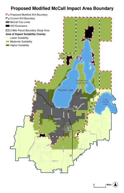
A draft map developed last month by the county would reduce the size of the impact area from more than 22,000 acres currently to about 684 acres, or by about 97%.
The draft boundaries included 135 acres around the McCall Municipal Airport, 90 acres in southeastern McCall on which Pine Creek Ranch is proposed by developer Craig Groves of Donnelly, and two state land parcels off Lick Creek Road near Pilgrim Cove.
Land surrounding Payette Lake would not be part of the impact area anymore, under the draft proposal.
The commissioners said their proposed boundaries, as well as the decision to reject the city’s proposal are based solely on new state law governing impact areas.
“Our task in all this was to look at the maps provided and determine if they meet state statute,” said Sherry Maupin, who chairs the board of county commissioners.
The law, adopted in 2024 by the Idaho Legislature, requires every county in the state to review existing impact areas for compliance with new criteria for determining boundaries.
The criteria include utility availability, anticipated growth, geographic factors, transportation infrastructure, and other public service district boundaries. It also requires land in impact areas to be “very likely” to annex into the city within five years.
Without donors like you, this story would not exist.
Make a donation of any size here
Lawmaker weighs in on intent
Differing interpretations of the state law driving the impact area review have hindered negotiations between the county and the city since last year—to the point that Maupin sought clarification from Sen. Todd Lakey, R-Nampa, who sponsored the bill in 2024.
Lakey affirmed that the area of impact is the county’s jurisdiction and said the “very likely to annex within five years” criterion should be met before the other criteria.
“If the city is not going to be there in five years, then that area should not be included in the AOI,” Lakey wrote in a July 22 letter to Maupin.
Lakey said updates to the law are meant to “focus” impact areas around lands where growth is likely to occur.
“The idea here is to be current and more precise or accurate,” he said.
City officials previously argued that the law requires all of the criteria to be considered, but not necessarily met.
However, commissioners on Wednesday said the five-year annexation window alone significantly restricts what land could be included in the impact area.
“There are even areas of our draft map that I have concerns with,” Maupin said.
Lakey also said the updated law is intended to foster more impact area collaboration between counties and cities—a mark Maupin said has largely been missed in negotiations with McCall.
“I think that we went down the road of collaboration until we didn’t,” she said. “I think that we have a chance to reset that as we continue to draw this map and continue down this process.”
