


New water quality protections and future growth maps proposed by Valley County are not enough to overcome the loss of the McCall Impact Area, according to the McCall City Council.
Last week council members were briefed on proposed changes to county zoning laws and the Valley County Comprehensive Plan, which is considered a “general guide” for administering development in the county.
The most major changes include the establishment of new building standards within 150 feet of any shoreline and countywide maps for forecasted growth.
The Valley County Planning and Zoning Commission will hold a public hearing on the proposal next Thursday, Oct. 23, at the Valley County Courthouse in Cascade. Written public comments can be submitted to P&Z Director Cynda Herrick until Oct. 15 at 5 p.m.
The county’s comprehensive plan, along with its zoning codes, are set to govern all development outside of McCall’s city limits come Jan. 1, when an administrative overhaul of the McCall Impact Area takes effect. That includes land around Payette Lake and fronting Idaho 55 south of the city.
McCall: changes ‘positive, but relatively minor’
McCall Community and Economic Development Director Michelle Groenevelt told council members the county’s proposed changes are “positive, but relatively minor.” She suggested a full rewrite of the county’s comprehensive plan and zoning laws would be beneficial.
“It’s probably time that they look at a bigger process, and we could always suggest that,” she told council members. “Obviously it’s their decision but I do think it’s important for us to comment on this because it will very much impact how development occurs around McCall.”
Council members agreed with Groenevelt, with Mayor Bob Giles calling it the city’s “obligation” to submit a comment to the county ahead of next week’s public hearing.
“We have to comment on this,” Giles said. “We have an obligation to represent our constituents and do the right thing.”
The city’s comment letter was not available as of Monday. The P&Z’s decision will be a recommendation to the Board of County Commissioners, which will make a final decision on the proposal.
New shoreline development standards
Outside of the McCall Impact Area change—an expected outcome following boundary negotiations between city and county officials this year—the most major proposed change is the creation of special standards for any development within 150 feet of “any lake, pond, river, or year-round flowing creek or stream.”
The Riparian Area Overlay—the name for all land within 150 feet of a shoreline—would require at least the first 25 feet of land fronting the shoreline to be devoted to native vegetation and erosion prevention features.
Without donors like you, this story would not exist.
Make a donation of any size here
Homes, condos, and other residential buildings would not be permitted within 50 feet of the shoreline, up from 30 feet under current county zoning laws.
Developments within the shoreline overlay area could also be required to build stormwater retention systems to keep run-off from the property out of Payette Lake, Lake Cascade, and other county waterways. Contractors working on the property would be required to hold stormwater training certifications to prevent construction run-off from polluting county waterways.
Use of fertilizer and “excessive clearing of vegetation” would not be allowed in the overlay areas, according to draft language.
The proposed standards would apply to all waterfront property in the county, including most of Payette Lake’s shoreline, which currently is subject to similar rules via McCall’s Shoreline and River Environs Zone.
Those rules, however, are set to be repealed by the county amid the administrative overhaul of the McCall Impact Area that is set to take effect Jan. 1.
Future growth maps
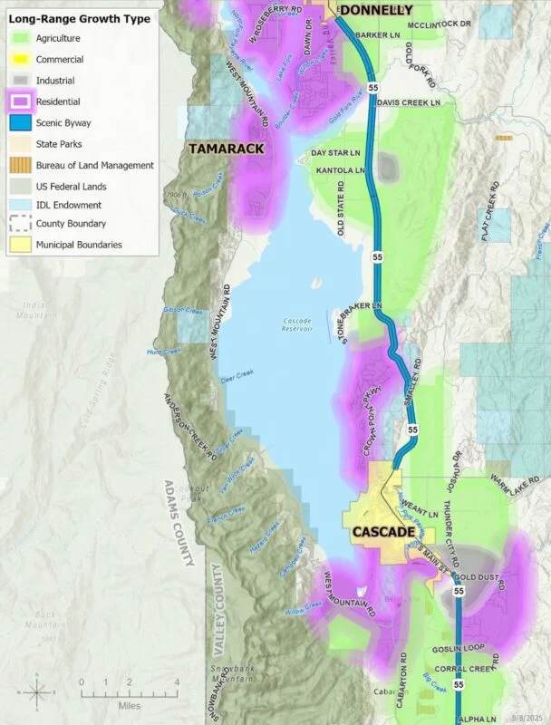
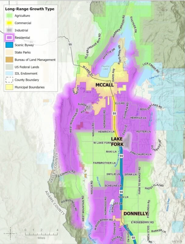
Updates to the comprehensive plan include future land use maps that forecast expected land uses in general areas across the county.
“Future land uses should be directed to the appropriate vicinity; but this does not disallow other types of uses,” the plan said of the proposed maps.
The maps show mostly residential development surrounding McCall, except for a strip of commercial development along Idaho 55 between the city and Lake Fork. Most of the land around the northern part of is designated as “agricultural” in the draft maps.
A large swath of land west of the highway along Lake Fork is also designated agricultural, along with land near Donnelly along Farm to Market Road.
Other proposed changes include new driveway standards to ensure proper emergency access and updates to facts, figures, and data in the plan.
City: lack of traditional zoning ‘could haunt us’
The need for countywide zoning was once again raised by council members last week when discussing the county’s proposal.
“Only two counties (in Idaho) don’t have zoning,” Giles said. “It’s time to get that changed.”
“It would serve their community and the taxpayer who’s paying for all this to have a more efficient system,” council member Julie Thrower agreed.
The county currently relies on a multiple-use system that reviews development applications for compatibility with surrounding properties instead of assigning zoning to determine acceptable types of development. The purpose of the process is to “grant landowners maximum flexibility in using and developing their properties,” according to the comprehensive plan.
Groenevelt described the system as a relic of Valley County’s rural past, calling it “antiquated” in the face of modern development pressures in the area.
“It’s a relatively easy system to administer for the county, but it does create it sort of a case-by-case basis, and there’s a lot of subjectivity to that process,” she said.
On Jan. 1, that system, along with county zoning laws, will take effect all around city limits in the former McCall Impact Area, as well as the reduced version that remains.
“This could haunt us, and the lake, in a really profound way,” council member Lyle Nelson said.
