


The McCall Impact Area should be expanded to comply with a new state law, the McCall City Council decided on Thursday night.
The council held a work session to discuss its proposal for revised boundaries of the city’s impact area, which is county land around the city that is subject to zoning laws that closely resemble those in city limits.
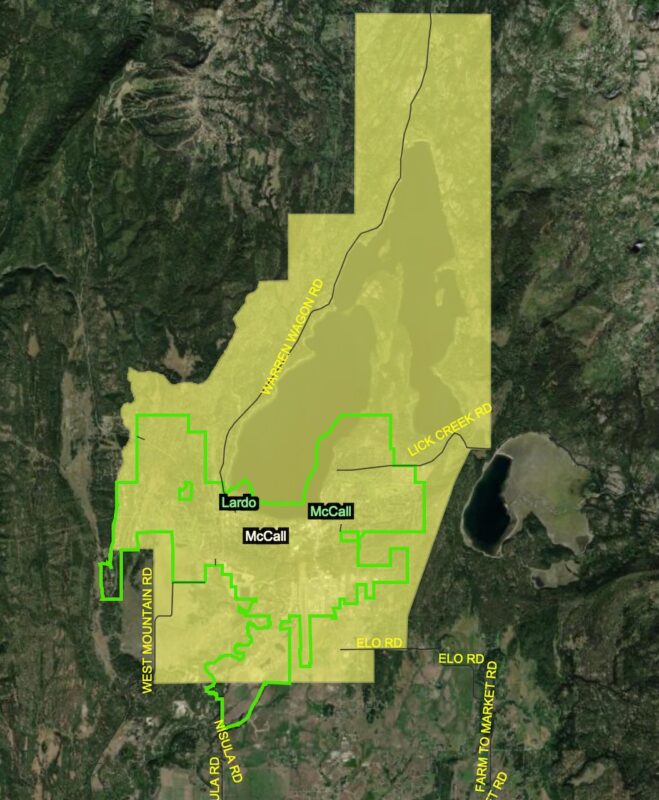
Two concept maps were presented to the council at the meeting. One of the maps expanded the impact area, while the other map kept most of the same existing boundaries.
Council members favored the map with expanded boundaries, known as Option A, and told city staff to move forward with that concept for a May 5 meeting with Valley County Commissioners.
The county has final say on the updated boundaries for the impact area, which must be adopted by Dec. 31 to comply with a new state law governing impact areas.
Southern boundary expansion
The Option A proposal favored by the council would extend the impact area’s southern boundary from Elo Road to near Johnson Lane, which intersects Idaho 55 at Franklin Building Supply.
“That area to the south…has a lot of commercial development pressure,” council member Julie Thrower said. “It worries me to just completely exclude that southern area, in particular, right now.”
Council member Colby Nielsen agreed, saying the Idaho 55 corridor south of McCall is at a “critical state.”
Option A also recommends expanding the impact area west into the Whitetail Club, east near Little Payette Lake, and around the northern part of Payette Lake so that it aligns with parcel boundaries, as required by the law.
The map was developed using criteria that the new state law requires to be used to inform impact area boundaries. Existing pathways, major roadways, utility services, anticipated growth, geographic features, and public services were among the criteria used to create 24 individual maps that were then overlayed to create Option A.
“What that does is it takes out any emotion,” Community and Economic Development Director Michelle Groenevelt said. “It’s just strictly a data-driven boundary based on the criteria.”
Groenevelt admitted she was surprised that the analysis recommended expanding the impact area, but said it aligns with future growth envisioned by city planning documents.
Without donors like you, this story would not exist.
Make a donation of any size here
“We just assumed it was going to be smaller when we plugged all this stuff in,” she said.
Over the last year, the county has suggested that the southern impact area boundary would be reduced because of limited utility availability in the area.
‘Status quo’ option
A second proposal, known as Option B, would keep the southern impact area boundary at Elo Road, but make the same adjustments to the far northern boundaries around Payette Lake.
Option B was framed as a “status quo” proposal by Groenevelt and City Manager Forest Atkinson.
Council member Mike Maciaszek was the only council member who favored proposing Option B to the county at the May 5 meeting.
“I don’t think we should be making anything more confusing or complicated at this point in time,” Maciaszek said. “We are not the decision makers.”
Atkinson agreed with Maciaszek and said Option B could result in a quicker resolution with the county.
“Sometimes getting to an agreement, the easiest thing for both parties is the status quo, because you’re not making any big changes,” he said.
Administration decision looms
A quicker agreement on the boundaries, Atkinson said, could allow the city and county more time to agree on how the agencies will govern the impact area moving forward.
Groenevelt reiterated the city’s desire to maintain the current system and emphasized the importance of applying city zoning laws, or laws similar to them, in the impact area.
“Quite honestly, if it just becomes Valley County unincorporated code, I’m not sure that it really matters where the boundary is,” she said.
Currently, the county adopts zoning laws that closely resemble those in place in the city. The county commissioners then make final decisions on recommendations made by a joint planning and zoning commission. The county has labeled that process as “very difficult” due to the different sets of rules.
Valley County reviews development applications using a case-by-case compatibility evaluation instead of assigning specific zoning to parcels like the city does. The agencies also have differing design standards.
In March, the county commissioners asked the city to suggest county code updates that could ease the city’s concerns with applying county code to the impact area. No such changes were discussed at Thursday’s meeting.
